Flood Plains

Be Flood Aware

Picture of a house surrounded by flood water

Contents of this Web Page:   Resource Information:


Contact Information:

City of Concord
Planning Department
Engineering Department
35 Cabarrus Ave W
Concord, NC  28025
704-920-5407


Flood Safety and Awareness

Scroll to Top

Concord has a population of 110,886 and comprises 64.4 square miles with 0.5% of the area being surface water.  Approximately 9.6% of the total city area lies within what is known as "Special Flood Hazard Areas" (SFHA).  These areas include floodways (i.e. areas where flooding routinely occurs) and 100-year floodplains (i.e. areas that have a 1% chance of flooding in any given year).  Flooding in Concord generally occurs in areas adjacent to rivers and streams, but may also occur in areas where water drainage is a problem.  In an effort to minimize the impact on human life and property, the City restricts and closely regulates development within the SFHA.  The Federal government and the State of North Carolina mandate that cities, towns, and counties adopt and enforce flood ordinances, as well as help educate the public about flood safety.  As a result of these local initiatives, citizens and business owners are eligible to purchase flood insurance under the National Flood Insurance Program and are entitled to a discount on associated insurance premiums.


Know Your Local Flood Hazard

Scroll to Top

Bodies of Water in Concord

Flooded area around houseThe City of Concord is located in the Pee Dee River Basin and is bisected by one river (Rocky River) and four major streams that mostly flow in a southeasterly direction. The major streams are: Coddle Creek, Irish Buffalo Creek, Three Mile Branch and Cold Water Creek. Additionally, there are several smaller streams and bodies of water that feed into these four major creeks. Eventually, all these streams converge into Rocky River, just south of the city limits.

All floodways and floodplains in Concord are adjacent to the major streams described above. Concord contains 5.576 square miles of floodplain, which constitutes 9.6% of the total city area of 63.627 square miles. Of this floodplain area, 2.053 square miles (3.2% of the total city area) is in the unbuildable floodway, with 3.523 square miles (5.86% of the city) in the remaining floodplain.

Lake Howell

Description:  Lake Howell is a man-made lake and serves as the primary water reservoir in Cabarrus County.  It is located just north of the Concord city limits off of NC Hwy 73 between Kannapolis Pkwy and Odell School Rd.  Access to the lake is restricted due to water quality protection measures.  In addition, the watershed that feeds water into the lake has certain land use controls.

Map image of water bodies in Concord

Map of Lake Howell


Lake Concord

Description:  Lake Concord is another man-made water reservoir in Cabarrus County.  It is located just northeast of the Concord city limits off of Centergrove Road.  Access to the lake is restricted due to water quality protection measures, and the watershed that feeds the lake has certain land use controls.

Map image of water bodies in Concord

Map of Lake Concord


Rocky River

Description:  Rocky River is the largest stream in Concord.  It has a continuous flow all year.  Flowing from northwest to southeast, it lies in the western portion of Concord.  Just south of Concord, the river flows in an south-easterly direction and eventually empties into the Pee Dee River south of Norwood, NC (approximately 30 miles from Concord).

Hazards that may exist:  Flooding in the floodway area, 100-year floodplain, and 500-year floodplain; flash-flooding events in the floodway and 100-year floodplain areas.

Past flooding events:

Map image of water bodies in Concord

Map of Rocky River

Map image of water bodies in Concord

Map of Rocky River with 100-year Floodplain area
(1% chance of flooding per year)


Coddle Creek

Description:  Coddle Creek is a perennial stream that is fed by Lake Howell (the Coddle Creek Reservoir) and empties into Rocky River in the southern portion of the City.  The creek flows in a southeasterly direction and lies in the western third of the City.  

Hazards that may exist:  Flooding in the floodway area, 100-year floodplain, and 500-year floodplain; flash-flooding events in the floodway and 100-year floodplain areas.

Past flooding events:

Map image of water bodies in Concord

Map of Coddle Creek

Map image of water bodies in Concord

Map of Coddle Creek with 100-year Floodplain area
(1% chance of flooding per year)


Irish Buffalo Creek

Description:  Irish Buffalo Creek is a perennial stream that flows southeasterly from the western portion of Kannapolis to the southeastern portion of Concord.  It empties into Rocky River at the southern end of Concord's city limits.

Hazards that may exist:  Flooding in the floodway area, 100-year floodplain, and 500-year floodplain; flash-flooding events in the floodway and 100-year floodplain areas.

Past flooding events:

Map image of water bodies in Concord

Map of Irish Buffalo Creek

Map image of water bodies in Concord

Map of Irish Buffalo Creek with 100-year Floodplain area
(1% chance of flooding per year)


Cold Water Creek

Description:  Cold Water Creek flows mostly from north to south along the eastern edge of the Concord city limits.  It empties into Rocky River just south of the city limits.

Hazards that may exist:  Flooding in the floodway area, 100-year floodplain, and 500-year floodplain; flash-flooding events in the floodway and 100-year floodplain areas.

Past flooding events:

Map image of water bodies in Concord

Map of Cold Water Creek

Map image of water bodies in Concord

Map of Cold Water Creek with 100-year Floodplain area
(1% chance of flooding per year)


Three Mile Branch

Description:  Three Mile Branch is a tributary of Cold Water Creek and lies just west of Cold Water Creek and east of Concord's downtown area.  The creeks runs next to NC Hwy 3 for its entirety.  It flows roughly from the cloverleaf intersection at I-85 and US Hwy 29 and empties into Cold Water Creek in the southeastern portion of the city.

Hazards that may exist:  Flooding in the floodway area, 100-year floodplain, and 500-year floodplain; flash-flooding events in the floodway and 100-year floodplain areas.

Past flooding events:

Map image of water bodies in Concord

Map of Three Mile Branch

Map image of water bodies in Concord

Map of Three Mile Branch with 100-year Floodplain area
(1% chance of flooding per year)


Areas Affected by Potential Flood Hazards

Flooding can present a serious threat to properties located in and along the flood hazard areas. Flood incidents generally affect road crossings that are subject to high water levels, and occasionally some structures are affected. According to FEMA records, Concord has four structures (houses or businesses) that have experienced a repetitive loss from flooding. 

See this list to determine if your address is on a parcel of land that contains 100-year floodplain.  This just indicates if the parcel may have some 100-year floodplain on it.


Current Stream Flow Conditions (flood water levels):

See stream gauge locations and data using this map.

All gauges in North Carolina

Local Gauges (with detailed information):


Flood Insurance

Scroll to Top

The Basics

What is flood insurance?

Flood insurance is a special type of insurance that covers damages to property that may occur due to natural flooding events.  Flood insurance can be obtained through insurance agents. Policies are available whether the building is in or out of a known flood-prone area.  However, flood insurance is generally only purchased by property owners (homeowners, renters, and business owners) if they have property located in or near flood-prone areas.  

Is there a waiting period to obtain flood insurance?

Yes, there is a 30-day waiting period before flood insurance can begin.

Is flood insurance available in the city limits of Concord?

Yes, since Concord participates in the National Flood Insurance Program (NFIP), flood insurance is available to homeowners, renters, and business owners.

Is natural flooding covered under normal homeowners insurance?

Typically not.  Flood insurance is a separate insurance policy from normal property insurance.

Where can flood insurance be purchased?

Flood insurance can be purchased from insurance agents.  Federal law makes it possible for flood insurance to be available in your local community (Concord).  FEMA manages the National Flood Insurance Program (NFIP). This program makes federally-backed flood insurance available in areas that agree to adopt and apply floodplain management rules to lower future flood damage.  The City of Concord is proud to participate in the NFIP and to help mitigate the effects of flooding for the local community, and to enable citizens to purchase flood insurance at a discount.  


Flood Insurance Coverage

What is covered with flood insurance?

Covered Building Property:

  • The electrical and plumbing systems

  • Furnaces, water heaters, heat pumps, and sump pumps

  • Refrigerators, cooking stoves, and built-in appliances such as dishwashers

  • Permanently installed carpeting over an unfinished floor

  • Permanently installed paneling, wallboard, bookcases, and cabinets. The damage must be directly caused by flood water. Cabinets that were not damaged by flood water are not covered, even if they match cabinets that were damaged by flood water.

  • Window blinds

  • Foundation walls, anchorage systems, and staircases attached to the building. There is an exclusion for “loss caused directly by earth movement even if the earth movement is caused by flood.”

  • A detached garage, used for limited storage or parking. Up to 10 percent of the building coverage limit can be used, but will reduce the total amount of building coverage available.

  • Cisterns and the water in them

  • Fuel tanks and the fuel in them, solar energy equipment, and well water tanks and pumps

Covered Personal Property - Contents:

  • Personal belongings such as clothing, furniture, and electronic equipment

  • Curtains

  • Portable and window air conditioners (easily moved or relocated) 

  • Portable microwave ovens and portable dishwashers

  • Carpets not included in building coverage (carpet installed over wood floors, etc.)

  • Clothes washers and dryers

  • Certain valuable items such as original artwork and furs (up to $2,500)

  • Food freezers and the food in them (but not refrigerators) 

View this Fact Sheet to learn more about what is covered.


Why Buy Flood Insurance

Normal homeowner's or renters insurance does not typically cover flood damage.  Most federal disaster assistance comes in the form of low-interest disaster loans from the Small Business Administration, and the money must be paid back.  FEMA may offer disaster grants that do not need to be paid back, but usually this amount is much less than what is needed to recover.  This leaves insurance as the other financial mechanism to recover.  

Flood events tend to affect the community mostly by the damage it can cause to property.  Even small amounts of flood waters can cause a large amount of damage.  Unfortunately, many property owners who are at risk are unaware that their property actually lies in flood-prone areas.  In addition, many of those property owners don't realize that normal homeowners' or property owners' insurance does not cover damage from flood waters.  

Property owners who own structures in the 100-year floodplain should definitely consider purchasing flood insurance.  Property owners in the 500-year floodplain should also consider purchasing flood insurance.  It is important to note that FEMA reports that nearly 30 percent of all flood claims come from outside the 100-year floodplain, according to statistics from the National Flood Insurance Program.  

Use this Data Visualization Tool and select Cabarrus County to see the historical flood risk.


Costs of Flood Insurance

What is the cost of flood insurance?

Flood insurance may be purchased from insurance agents.  The rates do not differ from company to company or agent to agent.  Insurance premiums are calculated based on factors such as: 

  • Year of construction

  • Building occupancy

  • Number of floors

  • Location of contents

  • Flood risk (as determined by the flood zone)

  • Location of lowest floor relative to the Base Flood Elevation on the Flood Insurance Rate Map.

  • Deductible and amount of building and contents coverage

The following examples for areas in Concord are given below.  These are just basic examples and estimates.

  • An average sized single-family home in a high risk area:  $12,000 - $18,000 per year

  • An average sized single-family home in a low to moderate flood risk area:  $1700 - $2700 per year.

  • An average sized single-family home in a low risk area:  $900 - $1300 per year.

Preferred Risk Policy is also available to homeowners in low to moderate flood risk areas (zones B, C, or X on the Flood Insurance Rate Map).  This type of policy may provide lower than normal premiums.

To learn more about the cost of flood insurance, visit FEMA's FloodSmart website.

Flood insurance estimates may also be obtained by using the Flood Risk Information System (FRIS) available at the State of North Carolina's Floodplain Mapping Program.  Simply search for your address and click on the building.  Insurance estimates will be shown in the menu on the right under "Flood Insurance".

Are discounts available?

As part of the National Flood Insurance Program (NFIP), FEMA administers a Community Rating System (CRS).  The CRS is a voluntary program which recognizes and encourages communities to exceed the minimum NFIP standards.  The CRS involves an audit of the community to determine a class rating number.  The rating number corresponds to a certain percentage discount that flood insurance policy holders are eligible to receive.

Concord holds a Class 7 rating under the Community Rating System.  This means that policy holders receive a 15% discount on their flood insurance premiums.  The discount system is listed below:

Class

Discount on
Flood Insurance Premium


1

45%


2

40%


3

35%


4

30%


5

25%


6

20%


7

15%

Concord

8

10%


9

5%


This Fact Sheet contains more information concerning the Community Rating System.


To Learn More About Flood Insurance

To learn more about flood insurance, visit the following resources:

FloodSmart.gov

National Flood Insurance Program (NFIP) web page


Protect Yourself and Others from Flooding

Scroll to Top

Warning Signals

Heed the flood warning signs.  Flash flooding usually occurs with brief, but intense, storms.  Water may accumulate rapidly in low lying areas, hence the term "flash".  Flooding may also occur with a long duration of rain, such as for multiple days in a row.  Tropical weather systems, such as during hurricane season, can bring large amounts of rain to the Concord area in a relatively short period of time.


When a storm is imminent or occurring:

Know the terms for alerts and warnings:

  • Flood watch – rainfall is heavy enough to cause rivers to overflow their banks. Flooding is possible.

  • Flood warning – flooding is occurring or very likely to happen in an affected river, lake or tidewater area. If told to leave, do so immediately.

  • Flash flood watch – flash flooding in specified areas is possible. Be alert! You may need to take quick action.

  • Flash flood warning – flash flooding is occurring or is likely to happen along certain streams and select areas. Get to a safe place immediately!

Stay informed.  Monitor the news or listen to weather radio.

Plan for how you will stay informed if there is a power outage.

Sign up for WaterAlerts from the National Weather Service to receive text or email messages when a stream in your area is rising to flood level.  Simply zoom in to a site on the interactive map, select the desired gaging station, and click "WaterAlert" to sign up to receive alert messages pertaining to that gaging station.

What to do During a Flooding Event

1.  Don't drive through flooded areas.
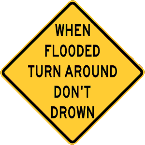
Warning sign - turn around, don't drownIn Concord, when flooding begins to occur, it generally affects low-lying roads that are subject to high water levels.  We don't often think about the power of water, but nevertheless, water is a very powerful force.  A small car can be swept away with just 12 inches of flowing water, and 18 inches can sweep away even some of the largest passenger vehicles.  Additionally, if water obstructs the exhaust system of the vehicle, the engine can stall and make matters even worse.  In most cases, it is difficult for drivers to determine how deep water actually is.  So, the best policy is to "turn around" and not risk driving through flooded areas.  

Turn Around image for video

Turn Around, Don't Drown Video
(presented by the National Weather Service)

 
Image of Flash Floods Video

Flash Floods - Turn Around, Don't Drown
(presented by Federal Alliance for Safe Homes)

Special message from Matt Hawk (singer/songwriter) and the National Weather Service


2.  Know the evacuation routes.

Having an advanced plan is the best way to avoid a bad situation.  Residents who live near flood-prone areas should have an evacuation route planned.  If the flooded route is blocked, know the alternate routes that will take you and your loved ones out of the area.  If flood waters come close to or enter your house, use an escape plan that you have prepared.

3.  Safety tips during an evacuation
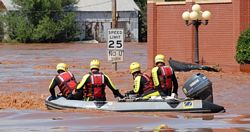
Image of a rescue boat floating in a flooded area

If a flood is likely in your area:

  • Listen to the radio or television to learn what to do.

  • Know that flash flooding can occur. If there is any possibility of a flash flood, move quickly to higher ground. Do not wait to be told to move.

  • Know that streams, drainage channels, canyons and other areas can flood quickly. Flash floods can happen in these areas with or without typical warnings.

If you must leave:

  • Secure your home. If you have time, bring in outdoor furniture. Move important items to an upper floor.

  • Turn off water, gas, and power at the main switches or valves if told to do so. Disconnect electrical appliances. Do not touch electrical equipment if you are wet or standing in water.

  • Do not walk through moving water. Six inches of moving water can make you fall. If you have to walk in water, walk where the water is not moving. Use a stick to check the firmness of the ground in front of you.

  • Do not drive into flooded areas. If floodwaters rise around your car, leave the car and move to higher ground if you can do so safely. You and the vehicle can be swept away quickly.

  • Do not camp or park your vehicle along streams, rivers or creeks, particularly during threatening weather.

  • It is recommended to take your pets with you.  It may be some time before you can return.

4.  Shelters

During a severe storm event, shelters may be opened to assist citizens with basic needs.  Please monitor communication networks to find out where shelters are in your area.  In some cases, the fire station locations in Concord will be opened as temporary shelters.  These may include:

  • Fire Station #3 - 100 Warren C. Coleman Blvd.

  • Fire Station #7 - 250 International Dr NW

  • Fire Station #8 - 1485 Old Charlotte Rd SW

  • Fire Station #9 - 1020 Ivey Cline Rd


What to do Before a Flooding Event

Being prepared is a process of planning for an event, and implementing the components of the plan at the right time.  To prepare for a flood:

  • Build an emergency kit and know how to use it.

  • Make a family communications plan.

  • Do not build in a floodplain without obtaining a permit from the City of Concord.  

  • Raise up the furnace, water heater and electric panel in your home if you live in a high flood risk area.

  • Think about putting in "check valves" to prevent flood water from backing up into the drains of your home or business.

  • If you can, build barriers to stop floodwaters from entering the building. Seal walls in basements with waterproofing compounds.


What to do After a Flooding Event

Document your damage

Use photos and/or videos to help document damage.  Retain samples of carpet, wallpaper, furniture upholstery, window treatments, and other items where the type of material may impact the amount payable on the claim.  Take photos of appliances (washers, dryers, refrigerators) and write down make, model, and serial numbers.  If possible, retain copies of receipts for these items.  

Mold and Cleanup

Minimize the growth of mold as much as possible.  NFIP flood insurance policies will not cover mold damage if a policyholder has access to the property and yet fails to take action to prevent the growth and spread of mold.  Download this guide to learn more about mold cleanup:  Homeowner's and Renter's Guide to Mold Cleanup After Disasters

File a Claim

Report your loss immediately to your insurance agent.  Have the following information available when reporting your claim:

  • Policy Declarations page

  • How you can be reached by phone or email

  • Property location

  • Name of mortgage company

Register for FEMA assistance at DisasterAssistance.gov

Prepare for Your Inspection

Enter the building only if it is safe.  Document the damage using photos.  Prepare the area for your insurance adjuster to visit.  Contact the building inspections department if your property was substantially damaged or if you need to obtain a building permit to repair the building.

Work with Your Adjuster

Your adjuster will show you their official identification and supply you with their contact information.  You should expect to receive an explanation of the NFIP flood claims process.  The adjuster will inspect your property and take photos.  They will explain what an advance payment is and how you can get one.

Create a Proof of Loss

Your adjuster will assist you in preparing a "Proof of Loss" statement, which is a sworn statement indicating the amount you are claiming.  The proof of loss must be filed within 60 days of the date of loss.

For More Information

What to Do After the Flood

Image of document


Flood Prone Areas

Flood-prone areas are those that are susceptible to flooding or are likely to flood.  These areas are mapped on the Flood Insurance Rate Maps (FIRM), and are made available by the Federal Emergency Management Agency (FEMA) and the State of North Carolina's Floodplain Mapping Service.

The City of Concord Planning Department is a repository of these maps.  Copies of the maps are available for download and for viewing at the department.


To Learn More

Concord Natural Hazard Mitigation Plan


Protect Your Property from Flood Hazards

Scroll to Top

Types of Damage

Flooding in Concord can occur from two primary sources:  rivers/streams and areas where drainage in inadequate.  Flood damage typically involves damage to foundations, sub-flooring, flooring, sheet rock walls, and insulation to name a few.  

Other types of damage may occur along with flooding, such as wind-related damage, as might be expected with hurricanes or tropical storms.  High-wind damage may also be related to severe thunderstorms which typically occur in the spring and summer months in Concord.  High-wind damage may tear off roofing shingles, siding, flashing, and break windows.


Maintain Drainage Systems

Flood prevention efforts depend on the community’s cooperation and assistance.  Grass clippings, branches, leaves, debris, and trash can accumulate and block natural and man-made drainage channels.  For example, a plugged drainage channel, catch basin, ditch, detention pond, or drainage pipe cannot carry water away from your property during heavy rain events.  Properly installed and maintained drainage systems are important in controlling and managing the flow of water on a property.  Maintaining these drainage systems is imperative to their proper function.  

The City of Concord also maintains drainage systems in the right-of-way and in City-maintained easements.  If these drainage systems become blocked, they may not function as designed.  Reporting blocked drains is important in managing the flow of water in the right-of-way.  Citizens may report damaged or blocked drainage systems by calling the City's Customer Service Department at 704-920-5555.

As a benefit to our citizens, the City of Concord offers a service to provide advice regarding drainage issues outside the right-of-way and City-maintained easements.  At the request of a property owner, we will provide communicative or on-site consultations and advice to address a drainage system issue. Please be aware that due to specific property characteristics the assistance provided may be limited. You should always consult a private professional before determining any course of action. Please contact our City’s Customer Service Department at 704-920-5555 to request a consultation. Please note that the City will not get involved in disputes between property owners.

Click here for more information about the City of Concord's Stormwater Services.


Retrofitting a Building

Retrofitting is making changes to an existing building to protect it from flooding or other hazards, such as high winds and earthquakes.

To learn more, download the guide below which outlines ways to protect your house from flooding.  This guide describes six retrofitting methods for you to consider as you think about how to protect your home from flooding.

Homeowner's Guide to Retrofitting:  Six Ways to Protect Your House From Flooding

The basic retrofit measures for flood protection are:

  1. Elevation - Raising your home so that the lowest floor or lowest horizontal member is at or above the regulated flood level. You can accomplish this in several ways. (Chapter 5)

  2. Relocation – Moving your home to higher ground where it will reduce the exposure to flooding. (Chapter 6)

  3. Demolition – Tearing down your damaged home and either rebuilding on the same property or buying or building a home elsewhere. (Chapter 6)

  4. Wet Floodproofing – Making portions of your home resistant to flood damage and allowing water to enter during flooding. (Chapter 7)

  5. Dry Floodproofing – Sealing your home to prevent floodwaters from entering. (Chapter 7)

  6. Barrier Systems – Building a floodwall or levee around your home to restrain floodwaters. (Chapter 8)

Check with a professional to:

  • Raise your furnace, water heater, and electric panel to floors that are less likely to be flooded. An undamaged water heater may be your best source of fresh water after a flood.

  • Install check valves in plumbing to prevent floodwater from backing up into the drains of your home. (As a last resort, when floods threaten, use large corks or stoppers to plug showers, tubs, or basins.)

  • Construct barriers such as levees, berms, and flood walls to stop floodwater from entering the building (if permitted by local building codes).

  • Seal walls in basements with waterproofing compounds to avoid seepage through cracks.


Emergency Flood Proofing

Emergency flood proofing includes techniques that can be initiated on relatively short notice using stored and/or natural materials to prevent flooding.  Emergency methods include sandbag dikes, earthfill crib retaining walls and stop log barriers. 

Use sand bags when flooding is expected:Sandbags to prevent flooding

  • It takes two people about one hour to fill and place 100 sandbags, creating a wall one foot high and 20 feet long.

  • Make sure you have enough sand, burlap or plastic bags, shovels, strong helpers, and time to place them properly.

  • If a flood is expected, some communities will offer free sandbags to residents. Be sure to watch or listen to the news so you can access these resources.

It is a good idea to plan ahead for these events.  For example, have a plan on where you might can get sand as well as sand bags.  Having the necessary tools, such as shovels and wheelbarrows, can be planned in advance as well.

Of course, once flooding begins, it is too dangerous to personally try to hold back the water.


Build Responsibly

Scroll to Top

New Construction in the City

All new construction within the jurisdiction of Concord requires a zoning permit as specified in the Concord Development Ordinance.  All new construction in Concord must have a finished floor elevation that is at least 2 feet above the elevation of the nearest 100-year floodplain.  This height above the 100-year floodplain is sometimes referred to as "freeboard".  FEMA defines freeboard as "an additional amount of height above the Base Flood Elevation used as a factor of safety (e.g., 2 feet above the Base Flood) in determining the level at which a structure's lowest floor must be elevated or floodproofed to be in accordance with state or community floodplain management regulations."


New Construction in the 100-year Floodplain

The City of Concord’s Planning Department administers the ordinances and regulations of the floodway and flood plain.  Development in the floodplain is restricted by the City's zoning ordinance (known as the Concord Development Ordinance), and requires a permit administered by the Planning & Neighborhood Development Department.  Regulations pertaining to floodplain development are located in Article 4 of the Concord Development Ordinance.  Proposed structures that would be located in a floodway (area that is routinely flooded) are not permitted in Concord.  Proposed structures that would be located in a 100-year flood plain are required to meet certain standards.  In most cases, it is not possible to build homes and businesses within the 100-year floodplain.

For further information or to report illegal or questionable development activities in the floodplain, please contact the Planning Department at:

City Hall
35 Cabarrus Ave W
Concord, NC  28025
704-920-5152


Rules for New Construction

For new construction, the builder is required to follow the procedures described below:

  • Apply for a Zoning Clearance Permit from the City of Concord.  This may be initiated at the City's web page or by calling 704-920-5152.

  • Apply for a building permit from Cabarrus County Construction Standards Division.

  • Follow the requirements for inspection from the Construction Standards Division.

  • Apply for a Certificate of Completion from the City of Concord.

  • Receive a Certificate of Occupancy from Cabarrus County Construction Standards Division.


Substantial Damage

"Substantial damage" means damage of any origin sustained by a structure within one year whereby the cost of restoring the structure to its before damaged condition would equal or exceed 50 percent of the market value of the structure before the damage occurred. 

Fact Sheet:  NFIP "Substantial Damage" - What Does It Mean?


Rules for Substantial Improvement

“Substantial improvement” means any reconstruction, rehabilitation, addition or other improvement to a structure, the total cost of which equals or exceeds 50 percent of the market value of the structure before the start of construction of the improvement.

The following procedures must be followed:

To learn more about Substantial Improvements:

Substantial Improvement and Substantial Damage


Laws and Ordinances

The City of Concord's Floodplain Ordinance is located in Section 4.7 of Article 4 of the Concord Development Ordinance.

The Building Codes for the State of North Carolina can be accessed here.

State Building Codes


Protect Floodplain Natural Resources

Scroll to Top

Concord's Floodplain Resources

Map of Natural Resources

Floodplains serve some very valuable natural functions.  During large rain events, the water in streams begins to flow very rapidly. It is this fast flowing water that can severely erode the stream banks causing sediment to be released. However, floodplains tend to lessen this effect.  When the water overtops its stream banks, the water spreads out.  This spreading-out of water provides several benefits.  First, the water velocities decrease.  The floodplain protects the stream banks by slowing the water.  Second, the floodplain stores a lot of extra water.  Floodplains are usually large open or wooded areas that are relatively undisturbed. These areas help store some of the storm water, reducing the flooding effects downstream. These largely undisturbed areas also provide storm water infiltration and filtering during smaller rain events. This filtering process is very important to maintaining healthy stream habitats and for improving water quality in our streams. In addition, these floodplains usually consist of some special species of plants that can provide important environmental benefits while being able to adapt and survive during wet flood periods. 

In Concord, you may notice parks occupy some areas of the floodplain. This is done for many reasons. Floodplain land is very useful during non-flood periods for recreation. Parks typically require few buildings and they also allow people to explore these natural floodplain areas and learn first hand about the benefits of water quality and floodplain protection.  Then, when the rains come, the water can fill these floodplains and we benefit from the many natural benefits of floodplains. City parks and recreation areas that have been developed in the floodplains include Caldwell Park, Dorton Park, Mickey McGee Park, Three Mile Branch Greenway, and the Hector Henry Greenway.  


Regulations

Regulations that protect our nation's natural resources are generally related to water quality protection, regulation of landfills, reforestation initiatives, air quality, waste management, and a variety of development requirements such as subdivision of land and landscaping requirements.


Natural Resource Protection

Protecting our natural resources is largely aimed towards prohibiting or discouraging activities which can damage the natural environment as well as restoring land to a more natural state.  

Land owners can help protect land for future generations by placing land into a conservation easement.  With such an arrangement, an easement is given to a third party entity, such as The Landtrust for Central North Carolina.  The easement specifies that the land would not be developed in certain ways.  As a result, the landowner may benefit from substantial reductions in property, income, and estate tax.  In addition, the property owner would have the satisfaction of knowing that the land would not be developed or at least have reduced development potential.  To learn more about land conservation easements, visit the Three Rivers Land Trust.

Cabarrus County Natural Resources Conservation Design Guide


FloodPlain Management

Scroll to Top

National Flood Insurance Program

Lady in flooded room

The National Flood Insurance Program (NFIP) is administered by the Federal Emergency Management Agency (FEMA), which is part of the Department of Homeland Security.  Community participation in the program is voluntary.  A community is defined as either an incorporated city, town, or part of a county that has a floodplain management ordinance and enforces the ordinance.  

When a community participates in the NFIP, flood insurance is made available from the NFIP.  In addition, if the president declares a disaster as a result of flooding, federal financial assistance is made available for the permanent repair or reconstruction of insurable buildings.  

As a participant in the National Flood Insurance Program, the City of Concord is listed in the National Flood Insurance Program Community Status Book.


Letters of Map Change (LOMC)

Click here to open up a list of the effective Letters of Map Change (LOMC) in the city limits of Concord.  This list includes Letters of Map Amendment (LOMA) and Letters of Map Revision (LOMR).  The individual LOMC documents are available in pdf format.

Locations of all the LOMCs in Concord can be viewed with the interactive map.  A pdf document of the LOMC can be opened by using the Identify button.

More information about LOMAs and LOMRs can be found by clicking here.


Flood Insurance Study

The Flood Insurance Study contains the description of the flood study, a description of the hydraulic model, and the flood profile charts.  These documents are used to help determine the elevation at which flooding could occur (measured in terms of height above mean sea level).

Volume 1 (pdf)
Volume 2 (pdf) 
Volume 3 (pdf)


Elevation Certificates

An Elevation Certificate is a form that is completed by a license surveyor.  It indicates the elevation of the Special Flood Hazard Area on a particular property along with the elevation of any buildings.  This information is useful in permitting as well as insuring a property against potential flood damage.  The City of Concord maintains a file of elevation certificates that have been submitted to the City.  Please visit FEMA's web page to obtain a blank copy of an Elevation Certificate.  Learn more about Elevation Certificates here.


Educational Resources

Scroll to Top

Books

The following books are freely available for download (as a pdf file) or are available at the local Cabarrus County Library:

Book - Above the Flood

Above the Flood:  Elevating Your Floodprone House

Download (pdf)


Book - Answers to Questions About the NFIP

Answers to Questions About the National Flood Insurance Program

Download (pdf)

&

Available at Library


Book - Answers to Questions About Substantially Improved Buildings

Answers to Questions About Substantially Improved / Substantially Damaged Buildings

Download (pdf)


Book - Elevated Residential Structures

Elevated Residential Structures

Download (pdf)

&

Available at Library


Book - Elevating Your House

Elevating Your House

(Homeowner's Guide to Retrofitting - Chapter 5)

Download (pdf)


Book - Engineering Principles and Practices

Engineering Principles and Practices for Retrofitting Flood-Prone Residential Structures

Download (pdf)

&

Available at Library


Book - Ensuring Structures Built on Fill

Ensuring Structures Built on Fill in or Near Special Flood Hazard Areas

Download (pdf)

&

Available at Library


Book - Floodproofing Non-Residential Structures

Floodproofing Non-residential Structures

Download (pdf)

&

Available at Library


Book - Guide to Flood Maps

Guide to Flood Maps

Download (pdf)

&

FEMA website


Book - Homeowner's Guide to Retrofitting

Homeowner's Guide to Retrofitting:  Six Ways to Protect Your House From Flooding

Download (pdf)

&

Available at Library


Book - Mandatory Purchase of Flood Insurance

Mandatory Purchase of Flood Insurance Guidelines

Download (pdf)

&

Available at Library


Book - Requirements for Flood Openings

Requirements for Flood Openings in Foundation Walls and Walls of Enclosures

Download (pdf)


Book - Protecting Manufactured Homes

Protecting Manufactured Homes from Floods and Other Hazards

Download (pdf)


Book - Protecting Building Utilities

Protecting Building Utility Systems From Flood Damage

Download (pdf)

&

Available at Library


Book - Protecting Floodplain Resources

Protecting Floodplain Resources:  A Guidebook for Communities

Download (pdf)

&

Available at Library


Book - Reducing Damage from Localized Flooding

Reducing Damage from Localized Flooding

Download (pdf)


Children's Resources

The following children's books may be downloaded and printed:

Children's Book - Sam the Disaster Horse

Sam the Disaster Horse

(an educational short-story and coloring book pertaining to natural disasters and safety)


Children's Book - The Great Storm

The Great Storm and Flood Recovery (with Parent Guide)

(a story and activity book to help children understand storm damage and their feelings about it)


Other Web Links

Scroll to Top

North Carolina Floodplain Mapping Program

Federal Emergency Management Agency (FEMA)

National Weather Service - Flood Safety


<thumbnail>

Map of Rocky River and Floodplains


<thumbnail>

Detailed Maps (showing parcels and buildings) 


<thumbnail>

Map of Rocky River and Floodplains


<thumbnail>

Detailed Maps (showing parcels and buildings)